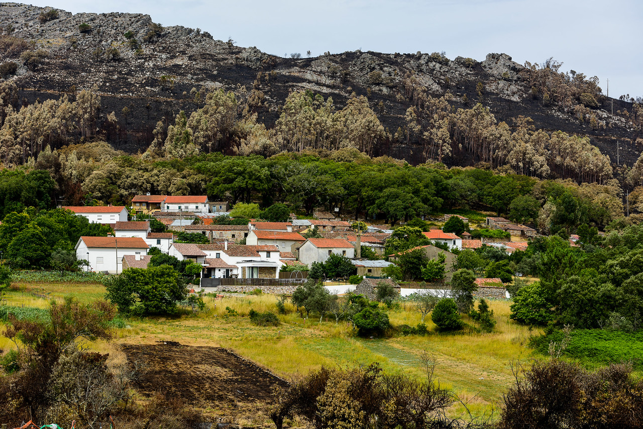
On June 17th, 2017, Ferraria de São João (hereafter Ferraria), a small-sized village in central Portugal remotely located at the top of a hill, was encircled by flames. The two available fire engines, one at each end of the village, were unable to refill with water at some point. There were no helicopters either. The tragedy, as the few residents would come to realise the morning after, was of a regional scale. Left to their own devices, the unprepared local population fought the flames by themselves with what they had at hand: garden hoses, water buckets, branches.
Wildfires are common in this region, but this time it was different. Indeed, 2017 was the worst wildfire year in Portugal’s recent history. A record area of over half a million hectares burned, leaving in its wake record damages and fatalities. Two unprecedented wildfire events, before (mid-June) and after (mid-October) the so-called critical fire period, were particularly disastrous, with over one hundred casualties and hundreds of injured people. These events were the first of a new kind recorded not only in Portugal, but also in Europe, in terms of extreme behaviour, intensity and impacts. In a way, Portugal was the “canary in the mine”, providing a stark warning of what the future holds for Mediterranean ecosystems.
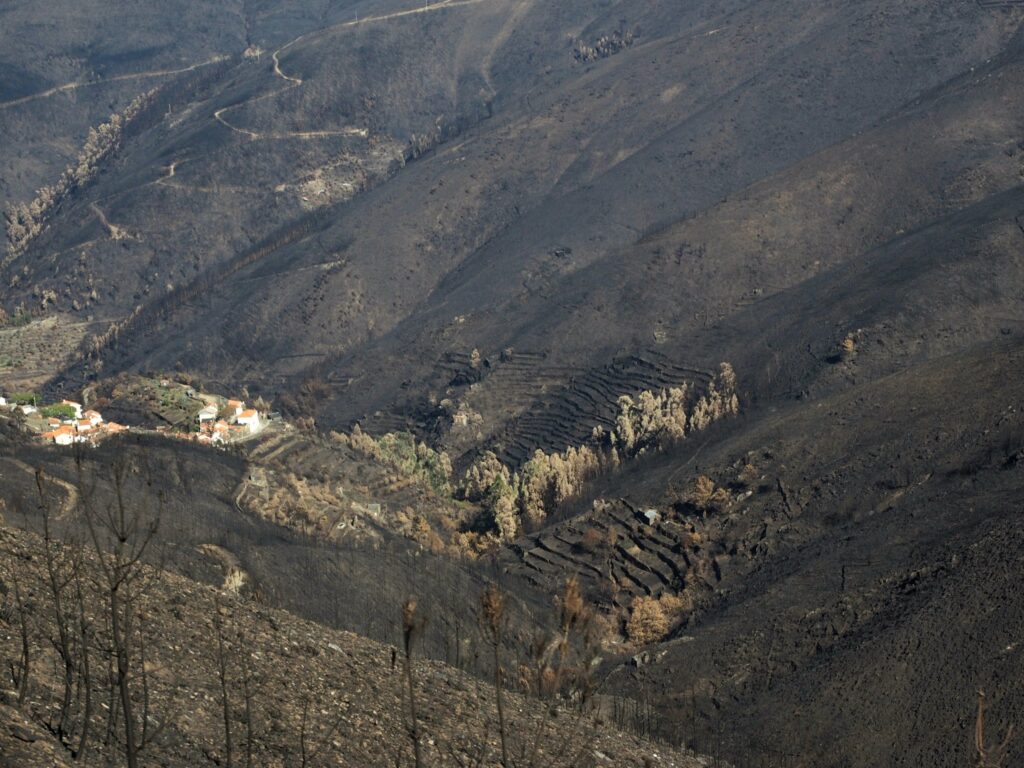
The roots of the wildfire problem in Portugal, and across Southern Europe more generally, are deep and complex, entangling social, economic, ecological, and political factors, further exacerbated by climate change. These roots date back to the 1960s, when significant socioeconomic and land-use changes radically changed fire regimes.[1] Since then, wildfires have become larger, more frequent, and more destructive. In the wake of a rapid, albeit late, industrialisation process, most rural inland areas of northern and central Portugal witnessed a massive rural exodus that left behind increasingly depopulated and almost abandoned villages. As a result, former agricultural areas have been occupied by fire-prone shrublands and forests. Forest composition has also shifted, due to plantations of native maritime pines and, more recently, non-native eucalyptus trees – two fast-growing, fire-prone species. Adding to this, forest ownership in Portugal is overwhelmingly private. In northern and central Portugal, where wildfires are more frequent, properties are also highly fragmented and small-sized. The owners of many of these properties are unknown, as most properties therein have no official land registry title – an issue that is only now being tackled.
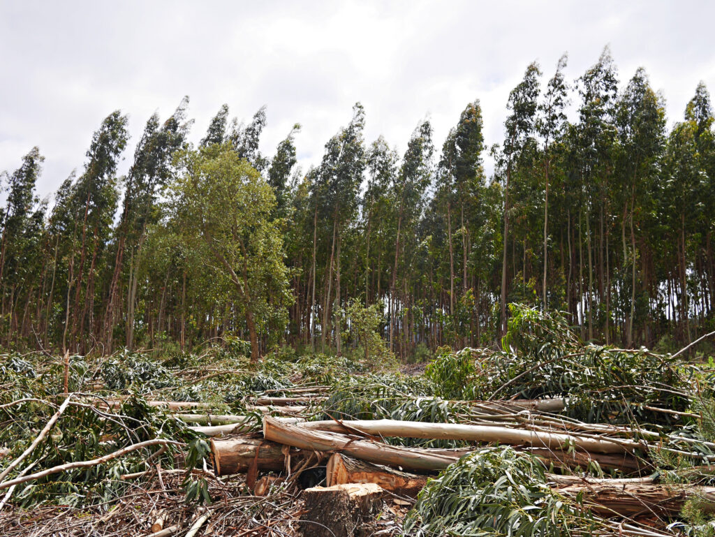
The eucalyptus is a controversial species in Portugal, where it is currently the most common tree. Native to Australia, it was introduced to Portugal in the 1850s, but it was only by the mid-20th century that it became a protagonist, often a vilified one, in the history of Portuguese forests and wildfires. Since then, the area it occupies has rapidly and steadily expanded to feed the booming paper pulp industry, not without protest, creating extensive monocultures, many of which un/mismanaged. Currently, Portugal has the largest land area planted with eucalyptus in Europe and, in relative terms, in the world. It is not only through planting that this species spreads, though. The eucalyptus thrives and takes hold with fire. In other words, wildfires encourage their natural regeneration. As many private properties are left unmanaged or abandoned, eucalyptus trees grow ‘wildly’, rendering landscapes increasingly flammable.
Like most villages in the region, the surroundings of Ferraria were almost exclusively occupied by eucalyptus, all of which burned down in 2017. Closer to the village, however, the flames eventually stopped in a 200-year-old stand of cork oaks, a heritage bequeathed by the ancestors that saved many houses.
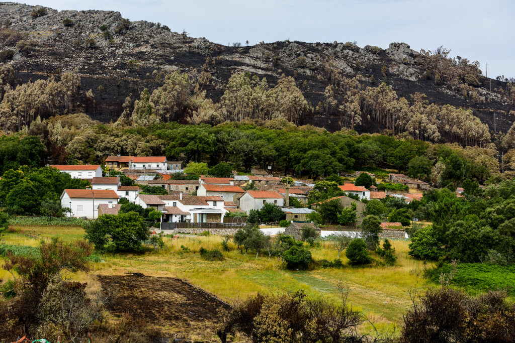
After experiencing the wildfires, and inspired by the oaks, the residents realised that something had to change. One week after the wildfires, the Residents’ Association promoted the first of over 20 community meetings with residents and forest owners to discuss what could be done to protect the village from future wildfires. Through a continuous participatory process of discussion and collective decision-making, the unanimous solution arrived at was the creation of a ‘village protection zone’ (VPZ): a 100-metres strip around the village collectively managed, where eucalyptus trees were replaced with more fire-resistant native trees.
The limits of the VPZ were collectively planned and mapped, as were the intervention areas therein. Given that the plots within the VPZ are mostly private, landowners’ consent was needed. The challenge was to identify them, as there was no land registry and many landowners are absentees. Yet, with the help of the residents, the Association was able to identify over 250 plots, mostly with less than 1 hectare, and their respective owners (around 80). Provided with the owners’ consent, the Association registered their lands and started removing eucalyptus trees in a designated area within the VPZ. Afterwards, over 1,000 native trees were planted. The areas and species to plant were also collectively chosen and mapped: fruit trees closer to the village; cork oaks and oaks further away. These plantations were made possible with the help of several volunteers from all over the country, taking advantage of the wave of solidarity that followed the catastrophic wildfires.
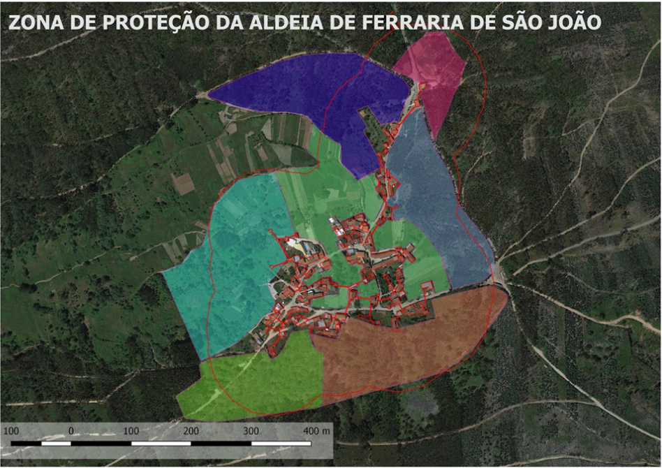
This pioneering and innovative initiative became an example at the national level, to be replicated in other villages, as has already happened in the neighbouring village of Casal de São Simão. These villages were two case studies in a research we conducted on local communities’ responses to the 2017 wildfires in Portugal,[2] as part of a larger interdisciplinary project on wildfire mitigation and adaptation in the country (People&Fire[3]).
With global temperatures on the rise and a projected increase of extreme wildfires due to climatic and land-use changes, to which Mediterranean ecosystems are particularly vulnerable, pressures mount to find ways to learn to coexist with wildfires. In a context of dwindling, aging population and widespread land abandonment, such as Southern Europe, what might this mean? What happened in Ferraria provides some answers. For the residents, it meant being proactive and restoring native landscapes through a bottom-up, participatory process that involved the whole community. The damaged, fiery landscapes of the present are not only “our disaster”, but also “our weedy hope”.[4]
[1] For a summary of these changes, see: Lourenço, L. (2018) Forest fires in continental Portugal: Result of profound alterations in society and territorial consequences. Méditerranée 130; Moreira, F. et al. (2011) Landscape–wildfire interactions in Southern Europe: Implications for landscape management. Journal of Environmental Management 92(10): 2389–2402.
[2] This research focused on ten initiatives that were implemented in one of the most seriously hit regions in 2017 (Pinhal Interior) by local communities, local associations and/or local governments. Drawing upon qualitative research methods (surveys of local government presidents, document analysis, and semi-structured interviews), it explored the underpinning motivations, actions undertaken, opportunities, and challenges.
[3] “People&Fire: Reducing Risk, Living with Risk” is a research project funded by Portuguese national funds through FCT–Fundação para a Ciência e Tecnologia, I.P. (PCIF/AGT/0136/2017), between 2019 and 2022. It is carried out at the University of Lisbon (School of Agriculture, Institute of Social Sciences, and Institute of Geography and Spatial Planning) and is coordinated by Professor José Lima Santos. The aim of the project is to develop a new analytical framework to support people-centred policies through changing practices and choices at the policy, collective, and individual levels.
[4] Gan, E., Tsing, A., Swanson, H., & Bubandt, N. (2017). Introduction: Haunted landscapes of the Anthropocene. In A. L. Tsing, H. Swanson, E. Gan, & N. Bubandt (Eds.), Arts of living on a damaged planet: Ghosts of the Anthropocene (pp. G1–G14). University of Minnesota Press.
Filipa Soares is a researcher at the Instituto de Ciências Sociais da Universidade de Lisboa. Originally trained as an anthropologist, she holds a DPhil (PhD) in Environmental Geography from the University of Oxford. She has done research in Portugal and the UK on various topics, such as the politics and histories of wildlife conservation, including rewilding, and forest management and human-environment relations. Email: filipafs@gmail.com
Luísa Schmidt is a sociologist and Principal Researcher at the Instituto de Ciências Sociais da Universidade de Lisboa. In Portugal, she pioneered environmental sociology research and outreach. She coordinates OBSERVA–Environment, Territory and Society Observatory and co-founded (2009) the PhD on “Climate Change and Sustainable Development Policies”.
Ana Delicado is a Research Fellow at the Instituto de Ciências Sociais da Universidade de Lisboa. Trained as a sociologist, she works mainly in social studies of science and technology. She has done research on environmental risks, energy technologies, public engagement with science, among other topics. She teaches at the PhD Programme in Climate Change and Sustainable Development and at the Master in Scientific Culture and Science Dissemination.
